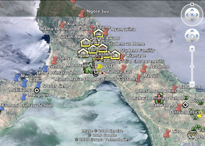
The ISIS Mapping Project partners with Duke Global Health researchers led by Sherryl Broverman and DukeEngage/WISER students to develop layered, multimodal, geo-located, map-based representations of a rural region in Kenya for research and discovery. Collaborators included Eve Puffer, Eric P Greene and many students and community members. Ongoing effort supported by the Center for Instructional Technology.
- Project Site (work in progress)
- Muhuru Teacher Technology Training 4/2010 (led by Richard Lucic in CS)
- ISIS Mapping site (how-to)
- Research.duke.edu news feature, 05/07/10 (PDF – minus media)
- Duke news video
- CIT Talk Slides 2009 (Instructional Tech Showcase 2009)