Durham • Tokyo • Chicago • Jerusalem • Turin • Athens • Venice

Month: May 2022

Malynda Wollert, Spring 2022

This semester I had the pleasure of working with the Visualizing Cities Chicago team led by Professor Paul Jaskot while also taking his class on Chicago architecture, which allowed me to delve into research with a full context of the sociopolitical history and architectural/building trends of the city. We began the semester by focusing primarily on mapping the spaces of Bronzeville around the time of the World’s Fair of 1933 to demonstrate the duality of the progress of the Fair and Bronzeville with the lived reality of racial and community violence. When we began brainstorming, I was intrigued by the role that drugs played in this dynamic, and I began my research centered around tracking sites of drug arrests and activity. Our research was almost exclusively conducted with information from the Chicago Defender —Bronzeville’s primary newspaper —database, so the articles that I found provided not only information about arrests, including the perpetrator’s addresses and arrest locations, but further contained commentary concerning the community’s perspectives towards drugs and their place within the Bronzeville community.

A primary takeaway of mapping these arrests was their proximity to well-known and respected community structures within Bronzeville; for example, the headquarters of an intrastate drug ring was down the road from the civil rights landmark of Pilgrim’s Baptist Church. This proximity was highly related to the perception of Bronzeville and the Black population by outsiders, and the reactions to this proximity from the Chicago Defender reveal fears of the effect of drugs on the community itself and the outside perception. An interesting example of this is a column written in 1937 that discusses the presence of coastal performers hanging out at the beach, in which the author accuses them of encouraging the use of cannabis and propagating its spread within the surrounding community. Many articles discuss the necessity of preventing drug use from spreading to local teenagers, and other articles concerning the arrests of teenagers for using/selling cannabis disparage how drug presence within Bronzeville leads to the stereotype of Black people and Bronzeville being associated with crime and warns parents of preventing their children from following suit. This proximity reveals how the perception of Bronzeville as a place of vice begins and becomes reality as other ethnic populations enter and use the city as such, encouraging crime.

Later in the semester, our focus slowly shifted away from the World’s Fair and towards a more general mapping of all the aspects of Bronzeville during the early 20th century. We separated into three groups— community, context, and conflict— to better contextualize and expand our project. I chose to work on conflict and expanded my area of focus to a more general definition of vice and crime within the context of the community, while my partners focused on points of conflict between Bronzeville and the rest of Chicago and on points of political conflict within Chicago that affected the community. An article that is representative of the conflict within the community discusses the abduction and rape of two contestants in the Negro Day Pageant during the World’s Fair. The Pageant, intended as a celebration of Black women within the community that was on display for the city and the world, was marred by these crimes and demonstrates how the community felt as though their success was always clouded by darkness and provides insight to how their achievements were destroyed in the eyes of spectators by vice.

I found working on this project immensely illuminating and interesting, and it ignited an interest within me to pursue projects within the digital humanities further. Visualizing these spaces provides a way to examine a city at both a macro and micro level, fusing together the importance of individual events within their broader context merely by being able to view them holistically through data representation. Moving forward, I am very interested in expanding the connections of these local crimes to a broader context of American life in this time to further understand the development of how perceptions and external factors can dramatically, and here negatively, affect a community, both local and national.

Kate Leonard, Spring 2022

The work of this semester took many of the ideas that Team Tokyo discussed last semester, and formed them into tangible work. Specifically, I collaborated with Felix, Surya, and Professor Wendell to visualize the Kasumigaoka Apartment Complexes and the movement of two individuals who once resided in the now destroyed apartments.  

We used many forms of media to investigate the history of Kasumigaoka. WIth the help of Matthew, we were able to track the change of Kasumigaoka and the surrounding area in Tokyo over time. Aerial maps taken from the 1920s all the way to present day were essential to our understanding of how the Olympics shaped the infrastructure and housing of Tokyo in the area. Through these aerial maps, we were able to see the construction and destruction of Kasumigaoka. We also utilized photographs and housing plans of the apartment complex to build a 3D model of the housing units using Sketch-Up. Sketch-Up–which Professor Wendell taught us how to navigate–allowed us to create something viewers could interface with and use to get a more complete understanding of the apartment complex.

Finally, we relied on interviews and other literature to chart the movement of displaced individuals who once lived in Kasumigaoka. We focused on the case studies of “J-san” and “S-san,” individuals who had given multiple interviews about their movement throughout their life and experience being evicted by the Japanese government. These stories were very powerful and distressing at times, and speak to the ways in which the Olympics does not always benefit a city and its people. J-san, born in 1933, moved early throughout their life because of the war. In between when they were born and then they moved to Kasumigaoka with their parents in 1965, J-san lived in Minobu, Fukushima, and various other locations in Tokyo. They stayed in Kasumigaoka for the longest period of time, living there until the Japanese government evicted them in 2013. The land, which is near the Japanese National Stadium and other buildings constructed for the Olympics, was taken to accommodate more Olympic infrastructure. Similarly, S-San was born in Fukugawa and then shortly after moved to Dailan, Manchuria for her father’s work on the Manchurian Railway Company. Following Japan’s defeat in WWII, S-san’s family was repatriated to Japan, where they bounced around to different cities until settling in Kasumigaoka in 1951. Similarly to J-san’s story, S-san lived in Kasumigaoka until being evicted and relocated to the Jingumae Apartments. All of this work can be viewed using this link and clicking the “view story” button. 

What I enjoyed most about this semester was the use of many different forms of media and archives. Most of my work at Duke previously relied on literature, written academic sources, and only occasional photographs or videos. It was a really unique learning experience to explore the topic of displacement in relation to the Olympics through old maps, photographs, and 3D models. I am grateful to have learned something new about Tokyo and the Olympics and even more grateful to have worked with such a wonderful team! Even as I graduate this year, I am excited to see how the lab continues to explore cities in the coming year!

Sana Hairadin, Spring 2022

My first experience joining the Tokyo Team in the Visualizing Cities Lab was at first intimidating but turned out to be immensely rewarding. It was invigorating to listen to everyone’s niche, comprehensive interests; however, there’s a sense of vulnerability that comes with sharing your insights to such knowledgeable peers– a feeling I learned to love. Initially, I appreciated the level of creative freedom fellows had in researching the 1964 Tokyo Olympics. It was through this research that I even got to explore a rich collection of Japan maps located in Perkins Library that I would never have known existed if it wasn’t for the much appreciated guidance of the faculty leading the lab. In just a few meetings, my perceptions of a city shifted from simply observing its exterior to questioning how space is used, including conversations about public vs private spaces and even the removal of spaces. 

While the Tokyo Team discussed the intersection of waterways, highways, and public spaces during the time of the 1964 Tokyo Olympics, I became particularly interested in the media that transpired as a reaction of a time period marked by Japan’s rapid economic growth and social change in the world sphere. On the Media Team, we brought attention to manner posters, which are a genre of public service advertisements that employ creative designs to remind train passengers of proper manners while using the public transport system. When observing the evolution of these Tokyo Metro posters, I decided to focus on how the imagery changed over time and investigate the connection between design and the other Tokyo teams research on transportation and housing. I discovered that with the booming growth of public transportation and an extreme increase in passenger volume/traffic frequency as a result of the 1964 Tokyo Olympics, a call for the diversification and extension of manner communication became formative for the Tokyo Metro. From boarding behaviors to the discouragement of littering, I conclude that manner posters hold a soft control on public transport morale that form a sense of collective among passengers by using popular, creative imagery. By distinguishing the changes in imagery (ukiyo-e vs superman) and the issued authority of posters (smoking vs use of mobile electronic devices), I learned that I could decipher a lot about the times in which a poster was created just by picking apart a single poster. Digging deeper into the politics of design, I was also able to unearth some pivotal events, such as The World Design Conference of 1960 that gave designs like the manner posters and pictogram designs from the 1964 Tokyo Olympics better recognition and ownership laws. 

The process of transferring a select number of manner posters onto Omeka made me curious about the different ways we could digitally present our findings along with other forms of media regarding the 1964 Tokyo Olympics. Simultaneously, I reflect on the personal growth I note exiting our Tuesday meetings with a distinct appreciation. I realize just how extensive the scope of this lab has the potential to be and I’m exceedingly grateful to have been a part of it this semester. 

Felicia Wang, Spring 2022

This semester, we built on last semester’s work on Bronzeville, Illinois by developing a more in-depth map on Neatline of historical locations and buildings. We also conducted more specific research into a greater range of subjects, such as historical monuments, arrests, and nuclear research, in 1930s Chicago. One of the biggest differences of this semester was the size and dynamic of the group, since we had over twice as many people as last semester. We engaged in large-group discussions about our topics every week, which helped me learn and think about how my topic, gospel music, intersected with the other topics like crime and gentrification.

Specifically, I researched how the evolution and “jazzification” of gospel music was perceived by various church choral directors. I stumbled upon this subject while continuing research on Bronzeville’s Pilgrim Baptist Church, the origin of gospel music. Gospel music combined the upbeat rhythms and swing of jazz with traditional church music to produce the clapping hymns we know today. However, some musicians, such as Professor H.B.P. Johnson, did not appreciate making the music danceable, claiming that it took away from the spirituality and authenticity of the music itself, especially if “jazzy” additions were made to another composer’s work. There is also an interesting dichotomy to be drawn between the nightclubs, where jazz was played, and the church, where gospel music was played. The church did not want to be associated with the “lower” lives and sacrilegious actions of the nightclub because they were working toward elevating the black community’s social status and perception in the eyes of others. These tensions were discussed in “Jazz Age Ruining Church Music, says Choral Director,” detailing an interview with Prof. Johnson in The Chicago Defender. Nevertheless, gospel music had an incredible impact on the Bronzeville community, inspiring the creation of music competitions with scholarships, national conventions to develop more community, benefit concerts to celebrate music education, and a sense of town pride for being the origin point of a national artistic movement.

The Chicago Defender contained a wide variety of sources to inform my research, including many advertisements and promotions for upcoming concerts, music competitions, and conventions. Prof. John Dorsey is depicted as a local hero, celebrated for all the musical and educational service he has contributed to Bronzeville and the black community across the nation. An article titled “Singers Plan Tribute to Prof. Dorsey” exemplifies how respected he was by local musicians, and this article was not alone in highlighting his many accomplishments and events organized in his honor.

Chase Pellegrini de Paur, Spring 2022

This semester in the Visualizing Cities Lab, I continued to work on the Chicago team under Prof. Paul Jaskot. While we spent last semester looking at the 1933 Chicago World’s Fair/Century of Progress Exposition through the lens of Black Metropolis, this semester the team shifted to zoom out a bit and include a larger variety of sources. We continued to rely heavily on the archives of the Chicago Defender, a Black-owned newspaper. We also shifted our timeframe to limit our research to about 1930-1945.

I started the semester looking at the nuclear research at University of Chicago in that period, specifically with the success of Chicago Pile-1, the world’s first artificial reactor. Chicago Pile-1 was the container for the first human-made self-sustaining nuclear chain reaction in 1942. The most interesting part of this story, however, is that CP-1 was located under the bleachers at Stagg Field at the University. This led to a bunch of great stories about foreign scientists like Enrico Fermi trying to remain inconspicuous while hustling around campus.

Continuing to follow the story of the bomb, the articles of the Defender continue to provide context for and reactions to the use of the bomb. The article that I found the most insightful was “Morals of Whites Dropped With Atom Bomb”, which expresses the disappointment of colored communities and countries with the decision of the “two leading Anglo-Saxon Christian Powers” (US and UK) to use the atom bomb against a colored nation. I had never thought of this perspective before, as the WWII history I learned in high school did not dwell much on reactions to the bomb, especially those from colored communities. Without using the term “white supremacy”, the article continued to link the ideas of whiteness to the atrocities carried out in Africa by Europeans over the centuries.

Finally, in continuing to build our Neatline exhibit from last semester, I joined the “Context” sub-team to try to build a sense of time and place into the map. I focused mostly on local politics, inspired by one of my teammate’s comments on the political machine of the time. I focused on City Hall as not only the official political center, but also the unofficial organized crime machine center. One encyclopedia referred to organized crime as the “grease” to keep the political machine running. I didn’t realize that Chicago still has a reputation for this even today. I found another source that mentioned Obama’s presidential run in 2008. Apparently, some of his opposition tried to claim that he was corrupt because he was from Chicago, and all those politicians are inherently corrupt.

In the future, I would like to look more into the politics of the Democratic machine in Chicago. There is certainly a lot of research out there that looks at the methods of organization beyond just the simple explanation of the spoils system that I would love to examine. I also wonder how the machine changed or influenced the physical landscape of the city that is experienced today.

Riya Mohan, Spring 2022

The Visualizing Cities Lab has been an eye-opening experience for me this year. As a returning member, I was astounded, yet again, by the innovation and creativity from my peers as we came up with new perspectives for analyzing the cities and expanding on ideas from the previous year. This semester, I had the opportunity to work with Team Chicago to better understand Black lives during the 1930s and 1940s. At first, the focus of our project was intended to better understand Bronzeville during the time of and the time surrounding the Chicago’s World Fair. Our main source of information and data was The Chicago Defender, an important newspaper for the black community in Chicago at the time and an invaluable source of information today. As time passed and as the team began to collaborate, the focus of the project became to focus more closely on the community within Bronzeville and mapping out the changes in centers of community over time. For instance, a few of the key terms for community we focused on included churches, clubs, education and more. Beyond community, we also focused on analyzing and mapping the contextual environment surrounding Chicago during the time period as well. This, as a result, gave us the opportunity to make new connections and understand community under a different light. Additionally, my main contribution was introducing the Provident Hospital to the discussions of community. After looking through The Chicago Defender, I came across an article that highlighted the important role the new hospital had within the community. The article especially highlighted the role various women from different social background had in the creation and maintenance of the hospital. My hope, for future semesters, is to better understand the role the hospital plays in terms of other health centers in the city, especially since the Provident Hospital was the first and biggest black-owned hospital during the time period. Furthermore, I also hope to better understand how the community surrounding the hospital interacted with other forms of community centers as well, such as the churches of Bronzeville, since many community centers overlap in various ways. Thinking more broadly of the project, I really appreciated the way our team used Neatline to display the work from our project. We used point-markers to mark and group important locations and had a time scale as well, so visitors to the project Neatline would be able to see the changes in community centers and contextual locations over time as well. This provided important value to the project as it allowed for visitors to gain a broader overview of Bronzeville as well as a more granular focus as well if they chose to dive deeper into specific points. My hope and goal is that the team will be able to continue working on and expanding this amazing project that we have started.

Kate MacCary, Spring 2022

I joined Team Chicago for the spring 2022 session of the Visualizing Cities Lab. Coming into the lab, I had only little bits and pieces of experience with the city of Chicago; my only exposure to the city in academic settings were through Professor Jaskot’s A Cultural Analysis of Ghettos course, and a graphic novel course I took that included a unit about Jimmy Corrigan (1893 World’s Fair). I came into the semester excited to learn more about the city and to join a team that had an existing digital project – an Omeka exhibit and Neatline map –that I could contribute to.

The Chicago team began the semester by generating ideas for topics we would like to study between 1933-1945 and how we would mine information about these topics from the Chicago Defender newspaper. I decided to focus on cultural and museum exhibitions; specifically, I used search terms and date filters (1933-1945) to identify articles and notices written for the Defender about local cultural events and exhibitions. This yielded a handful of interesting results, and most articles responsive to these search parameters were exhibition reviews or notices. One article from June 3, 1933 notes the diversity of art in the Art Institute of Chicago’s collection, and how visitors to the World’s Fair could see art from all over the world at the Institute. Another article dated September 26, 1942 discusses how contemporaneous  programs by the Art Institute (the “Negro Exposition”) and the Southside Community Art Center promoted artistic endeavor and access for African American Chicagoans. I also expanded the search beyond the Art Institute, and found notices for art exhibitions at the Southside Community Art Center and World’s Fair. Regarding the former, a Defender article gave a review of the fall 1942 exhibition “Chicago’s Most Photogenic Women” at the Southside Community Art Center. An article from September 29, 1934, reviews an art exhibition by Wilberforce University art professor C. H. Johnson at the Century of Progress World’s Fair; Johnson’s exhibit celebrated the progress of Black Americans in the preceding century. The exhibition consisted of paintings, photographs, and handcrafts – all of which were noted for being laden with symbolism. I added points to the Neatline map corresponding to the locations of exhibitions (e.g., Southside Community Art Center; Johnson exhibit at the World’s Fair).

Around the mid-term period, Team Chicago opted to use three conceptual categories to map and guide our exhibition. We settled on the categories of “Community,” “Context,” and “Conflict.” I opted to study “Context,” which comprises all of the urban development and organization lessons that we have learned from Chicago. (Our sub-team adopted the motto “lessons learned.”) For this phase of the project, I turned to the Encyclopedia of Chicago, and reviewed entries related to infrastructure and institutional administrative bodies in the city. From there, I narrowed my focus to the Chicago Housing Authority and the Chicago Transit Authority. I reviewed the major projects by these entities and asked myself, “What are the lessons we can learn from this project? Was it a success or a failure?” I added a point to our team’s Neatline map to correspond with the Cabrini-Green housing project. I felt that this project presents important lessons for public housing authorities and should be highlighted in our map.

Team Chicago’s spring 2022 project has been fruitful and interesting. I personally now have an interest in Chicago, and am excited to continue uncovering the lessons in urban development of the Second City.

Joy Liu, Spring 2022

For the Spring 2022 semester, as a member of the Chicago team, I was onboarded with the continued work on the mapping of Bronzeville, Illinois. At the beginning of this semester, team Chicago continued to focus on mapping the relationship between the Chicago World Fair of 1934 to the social-political atmosphere of the Bronzeville community throughout this time period. Using Neatline and Omeka, our team mapped historic events as recorded by the Chicago Defender, a Chicago-based historical African American newspaper that is deemed to be reflective of the African American community, specifically the Bronzeville community. Combining the spatial data with historical event information, we aimed to create an interactive Omeka exhibit. As a member of the Chicago team, I focused on monuments and memorials within the Bronzeville community. I wanted to explore African Americans’ representation in the commemoration of the Civil War and the First World War.

In my research, I specifically focused on researching the Chicago Victory Monument, a marble and bronze structure erected at the intersection of 35th Street and King Drive, the heart of Bronzeville in 1927. What was especially interesting about this particular monument is how the bronze panels surrounding the marble and the soldier atop the monument were added 9 years later in 1936. The Victory Monument is culturally significant in that the Bronze Panels and the soldier that were added later were the first government effort in honoring African Americans’ contribution to the World War. More specifically, the monument honors the meritorious achievements of the Eighth Regiment of the Illinois National Guard, an African American unit that served during World War I in France as part of the 370th U.S Infantry. At the second dedication ceremony of the Victory Monument, Representative Charles J. Jenkins and Chicago mayor Edward J. Kelly praised soldiers’ deeds. During the Chicago World Fair, an exposition aimed to recognize the American progress, the dedication of the Victory Monument, and the recognition of African American achievement paralleled the progressive atmosphere in Chicago in the time of 1933 to 1945. While my research surrounds the topic of African American progress, my peers have focused on instances of race riots, voting suppression, and discrimination targeting the Bronzeville community. Our research revealed an interesting contrast between the community’s continued social issues and the progress it has made. This concept of contrast spring-boarded team Chicago’s later focus on expanding the project scope beyond the Chicago Defender and looking at Bronzeville through the lenses of community, conflict, and context. Working within the conflict team, I focused on exploring ways the community progressed that juxtapose the tension and setbacks. For example, the success of the first world fair took place in the Chicago Coliseum which focused on noting the accomplishments of African Americans in 1940.

Throughout this semester as a part of the Chicago team, I learned a lot about Bronzeville’s history and social culture through the lenses of the Chicago Defender. More importantly, I learned how to recount a story using spatial data. I’m excited to see how our exhibit develops if we have more time to add more resources and pieces of information.

Jeffrey Hwang, Spring 2022

For the past few months of my spring semester, I was on the Tokyo Team as an undergraduate planning fellow in the Visualizing Cities Lab. More specifically, I specialized in Tokyo Visual Media surrounding the 1964 and 2021 Tokyo Olympics, one of 3 other sub-groups (transportation and maps). In my group, we primarily discussed and retrieved archival materials to explore the impact of visual media on diffusing the Tokyo Olympics, how such materials were designed, and their implications on Japanese society. Our work integrated well into our whole-team sessions as well where we explored how maps and digital tools can be used to analyze relevant sources like maps to improve accuracy. My semester with the Tokyo team has been overall crucial for me to develop an interdisciplinary understanding of the Tokyo Olympics (I didn’t even know that there was a 1964 Tokyo).

Most of my time as a fellow was devoted to the Tokyo Visual Media sub-group. What first piqued my interest in Tokyo visual media was the vintage media book that Professor Weinstein bought one day. Before I entered the lab, I already had some experience with Japanese historical research. Last semester, I had researched and produced a mini-documentary on the history and commentary surrounding the Japanese women’s-only train system in the Gender and Political Economy class. There I was first exposed to the mannerism posters we discussed in the Tokyo team and the media book showcased. My still burgeoning interest in visual media and design further bolstered with urbanism eventually drove me to join the visual-media sub-group team. In the team, I was exposed to so much Japanese Olympic history that I had not encountered before. In particular, I was intrigued by the radical Hi-Red arts movement and the heavy investment in universalizing communication in the Olympics.

The Hi-Red movement was an arts collective where avant-garde artists made public art demonstrations to draw attention toward governmental urban reform. Upon being selected as the 1964 Olympics host, the government and corporations saw this as an opportunity to regain economic, cultural, and social capital on the world stage. Thus, mass sanitation, cleansing, and reconstruction efforts were implemented causing mass displacement and relocation in the Tokyo area in order to make the city “presentable” for the global audience. Hi-Red interrogated and fought against such commercialism and mass reform by targeting the authenticity and ethics of them. Seeing pictures of their demonstrations and reading about them was very fascinating.

The 1964 Tokyo Olympics were also the first Olympics to have used modernized graphic design. The consistency of Helvetica and adoption of pictograms were evidence. In order to bridge linguistic and cultural barriers, pictograms were designed to universalize communication, especially the events. My group spent a session analyzing the pictograms and we found an evolution in visual representation between the first and second Tokyo Olympics. The silhouette of 2021 bodies tended to be slimmers and sleeker. Shapes also had more rounded edges. We suspected that this may have been a manner to make the pictograms genderless to further universalize them. There, however, was still a great amount of noticeable similarities between the first and second Olympic pictograms. Some were almost the same in design. The visuals’ purposes were clearly used for Japan’s entrance into globalization.

I noticed this trend, when I was finding visuals to upload onto Omeka. Among the many graphics I encountered, I eventually selected a picture of Downtown Tokyo and the packaging and advertisements of Japanese Tobacco. The picture was of Downtown Tokyo one year before the 1964 Olympics, and corporations had altered the urban form with bright signs and rotating contraptions. The visual commercialization of the area seemed like it was fantasizing Tokyo to make the city palatable for foreigners. Conversely, tobacco packaging was geared toward Japanese citizens who were also enthusiastic about the competition. Packaging integrated the Olympics and even included limited-time promotions.

Overall, this in-depth exploration of visual culture was fascinating. Being a fellow at the Visualizing Cities Lab has propelled my passion for visual design and global urbanism.

Sunny Gao, Spring 2022

I am very glad to continue to join VCL this Spring, and I am very excited to see the richness and changes of the conference content, based on last semester’s lab schedule, we have added a lot of precious time for professor’s lectures this semester. At the same time, the lab is more focused on teamwork and discussion, and there are separate teams within the Chicago/Tokyo team to work on different topics. This makes the one-hour meeting time on Tuesday afternoons very valuable and exciting.

This semester, I am new to the Chicago team and starting a new journey of exploring urban issues. Our Chicago team visualized social and cultural histories in the city’s spaces. We began by surveying Chicago’s major neighborhoods to gather information about their social histories, migration patterns, institutions, and spatial development. The main task was to start with a major article on the fair published in the Guardian and try to pick out some themes. We linked them to some readings we did in the very important publication Metropolis Noir (1945), a sociological and cultural study of Bronzeville. So we started making an Omeka/Neatline map to help us think about the main themes in Bronzeville during the publication of the fair and Metropolis Noir (1934-1945). Because I don’t have much research and knowledge about Chicago, the most impressive thing is that this is the prototype of Gotham City in the movie Batman, the capital of sin. So initially, I focused on the issue of social security, what caused Chicago to remain chaotic today, is it a historical legacy? So, I found two articles in the Guardian that had a specific geographic basis, first, Introduction of Jim Crow in Chicago Suburb Leads to Riot. And the second was Army Race Riots Grow! Through these two reports, I learned that much of the unrest at the time stemmed from racial issues, and that the damage continues to this day. We then explored how to bring everyone’s information together on the Neatline map, how to use the timeline to present the information, and what colors to use to mark the dots. Finally, we completed this socio-spatial map, using Context, Community as shifting approaches to explore the main topic. For Context: Regal Theater, Southside Community Arts Center, CHA; For Community: People’s Forum Medinah Temple.

We actually put together some reflective discussion questions for the final meeting but couldn’t carry them out at the time due to time limitations. If you have a chance to read this blog, I hope it can cause some of you to think about it. What were your workflows, challenges, limitations, and triumphs? What major connective themes have you noticed through engaging in the cities of VCL? What were your takeaways, aspects that you want to input into their own interests (anything from course syllabi introduced in VCL)? Would you like to continue exploring urban issues in the future? For the last question, my answer is yes! I am grateful to VCL for giving us an opportunity to explore a common and dynamic approach to studying world cities. It was an honor to meet all the professors and students at VCL, and I look forward to seeing you again on campus in the future!

Richard Gao, Spring 2022

This semester, I worked in the Tokyo Team and grouped with three other undergrads to explore how the 1964 Olympics brought about changes in social media. Specifically, we focused on manner posters, which illustrated the social conducts that passengers were supposed to follow in the public transportation space, especially the metro stations. While the two other groups explored issues on a larger scale, such as the evolution of Tokyo’s transportation lines and public housing, our focus on these images revealed how government reinforced social conduct by appealing to elements from the pop culture. We decided to archive and present these images through entries in the Omeka.

I will discuss two of my favorite manner posters and interpret the language encoded by the visual elements. The work Dream at Home was posted during the Christmas of 1981, which was a time for friends and couples to meet up for parties or dinner in Japan. It was a time when many people got drunk, fell asleep on the subway train, and missed their stations. This poster spoke to this phenomenon by incorporating characters from the manga series Doraemon, widely popular for the imaginative stories of a robotic cat from the 21st century. In the image, Doraemon dresses up as a Santa Clause and Nobita’s father is sleeping soundly, whose Santa head and the gift box add to the festive atmosphere. The bold read headline “Dream at Home” clarifies the purpose of this poster——encouraging drunk people not to pass out on the train. This poster alludes to pop culture and incorporates the holiday-specific elements to teach passengers the manner of staying sober on the train.

The other piece embodies more modern and representational elements but also alludes to a Japanese tradition——hanami (flower viewing), indicated by the silhouette of cherry blossom petals on the background. This was a time when Japanese people held outdoor parties under the sakura trees. The image features a bright pink background with a heart shape cutout. The pink color together with the green suit reminds people of the vibrancy and warmth of Spring. While a man jumps up to rush through the closing subway door, a woman opens her mouth in surprise, illustrating the danger associated with this behavior. The text below the figures reads: “ At the beginning of new life, be slow and be smart.” This points to the major theme of this poster——Don’t squeeze in when the subway doors are about to close.

My studies of manner posters in the Tokyo Team inspire me that urban research is like putting together puzzle pieces. While there is no single definition of cities, the multidisciplinary approaches we adopted help reconstruct a more thorough, vivid, and realistic image of cities. For example, while focusing on the evolution of public transportation lines enriches our understanding of how urban transportation plays with other socioeconomic factors such as industrialization and event such as the Olympics, our focus on the manner posters reflects how government shapes social customs in the urban space. In the future, I will expand my research to explore other forms of media, such as street graffiti, and reflect on what they tell us about urbanization.


Felix Borthwick, Spring 2022

As an anthropologist, it feels easy to write about cities. Some of us spend a lot of time in them, working with others who live and breathe urban space daily. This gives us a richness of experience, which we then try to use to say something about life in the city itself. But teaching others about cities is a different matter. What one writes about a given city does not necessarily have any inherent pedagogical value – other processes must intervene before something become ‘teachable’.

I joined the VCL with this concern for ‘teaching the city’, as it’s something I expect to do myself one day. Other questions quickly emerged: How can we teach the city visually? Though anthropologists do often incorporate visual material, they are still a very text reliant lot. I was interested in how we could use the ‘visual’ as an entry point in a way that remained faithful to the ethnographic experience of the city that anthropology holds so dear.

My last question surfaced during Team Tokyo’s initial discussions. Anchored in the 1964 Olympics, we leaned into the use of historical visuals to explore Tokyo’s changes around that time. But, stealing from Marx, all that is Tokyo melts into air. My research on Japan’s postwar public housing (danchi) has taught me that cities like Tokyo present us with a profound problem because they constantly change. Though at least 400 years old, modern Tokyo’s architectural record is astoundingly thin. This historical poverty begets a visual poverty: you can’t really ‘see’ the historical layers of Tokyo because so much of it is gone. How do we teach about something that is no longer there?

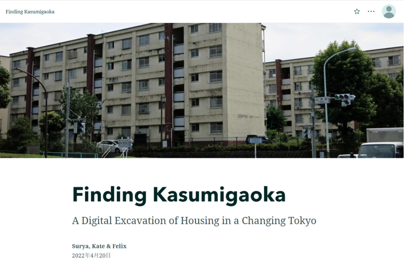
With all this in mind, the Housing sub-group’s project began with Tokyo’s 2020 Olympics. Several news articles told remarkable stories of now-elderly residents who had been evicted from their homes for Olympics-related redevelopment not once, but twice – before both the 1964 games and the 2020 games. One main site emerged: Kasumigaoka Apartments, a public housing project constructed during the pre-1964 wave of urban renewal that was then demolished during a similar wave before 2020.

Kasumigaoka Apartments, c. 2015
(Source: http://sanpototabi.blog.jp/archives/1047891515.html)

Kasumigaoka became our focus. Thankfully, there was a wealth of online textual information that helped us trace its history. But visual materials were essential here too: working with aerial photography of the Yoyogi area from the Geospatial Information Authority of Japan, we could track the changes the Kasumigaoka site had undergone since the 1930s. Things mentioned in interviews with former residents – Kasumigaoka’s construction in the early 1960s, the nagaya tenements that occupied the site earlier – suddenly had visual form.

1948 aerial photograph of Yoyogi area, showing nagaya tenements (center-right)
(Source: Geospatial Information Authority of Japan)

Armed with text and image, our group decided to digitally excavate Kasumigaoka. We had two immediate aims: tracking the development of the site to see how public housing typologies changed from the 1940s to the 1960s; and tracing the life paths of former residents to see how people moved through Tokyo, Japan, and the world before settling in Kasumigaoka. This historical ethnography would, we hoped, tell us something interesting about historical change and life experiences in Tokyo.

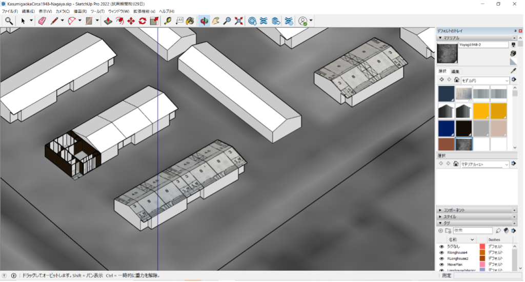
Relying on a combination of aerial photography to reference site layouts and contemporaneous floorplans, we used SketchUp to develop 3D models of the 1948-1963 tenements and the 1964-2016 Kasumigaoka complex. We also compiled a list of all the places each interviewed resident had lived in and the accompanying dates to plot spatially later. We integrated these elements via StoryMaps, bringing together contemporary photographs of Kasumigaoka, aerial photography of the changing site, the 3D models, and dynamic maps that tracked two residents’ paths through the city and the world. This combination of different sources helped us tell the story of Kasumigaoka – a microcosm of urban change in Tokyo.

3D SketchUp model of nagaya complex, based on 1948 aerial photograph and contemporary floor plans

Learning to use SketchUp and StoryMaps was a major takeaway from this process. But beyond mere technical pickups, this experience showed me the importance of digital visualization as a research and pedagogical tool. The hands-on process of building site models gave me insight into the materiality of the site itself in ways that escape traditional research methods. And these models, in concert with photography and maps, let us introduce others to a site that no longer existed in an immediate and interactive way. Anthropologists like myself – always interested in the ever-fleeting now – can use these tools to creatively engage with (and engage others with) what is no longer there. Visualizing the city through the creative use of technology thus bridges several gaps: the city’s past and present, urban history and urban anthropology, the virtual and the material, and pedagogy and research.

Selections from the final Kasumigaoka StoryMap

Charlie Colasurdo, Spring 2022

Now a fourth-semester VCL fellow, I’ve been fortunate enough to be exposed to various cities and methodologies by which my respective teams have examined them. In this semester, Team Tokyo engaged with the East Asian Megacity’s development in the latter half of the 20th century. Postwar Japan provided a unique and fertile ground for urban experimentation, with a relatively “blank slate” as a result of the destructive impact of the war. This resulted in a variety of experimental urban planning strategies and tools, from the Olympic Village in Tokyo in 1964 to the development of the Shinkansen, the bullet train that revolutionized domestic transit and urbanization. Our team brought together a variety of Japanese experts and neophytes on the subject (including myself). It was fantastic to hear about Tokyo from the perspective of public housing, government policy (like the famous ‘manner posters’), and the creation of a distinctive soft power through anime and other elements of Japanese visual and culinary culture. As an urbanist, I appreciated the conversations about Tokyo which engaged with the more granular everyday life of the city, particularly in small neighborhoods, and also extended these to the macroscopic perspective of the city and surrounding region. I especially was interested in the relationship between Tokyo’s built environment, food culture, and tourism—a confluence of factors I have previously engaged within Bangkok. My partner Natalie and I are working on a presentation on Tokyo’s transit—often looked at as the gold standard for metro systems, as well as the Shinkansen network. Both systems have facilitated extensive urban development within Tokyo itself, and also connected the city to the rest of Japan’s conurbations. The city’s metro system has been essential to ensuring Tokyo’s citizens have cheap, accessible, and efficient means of public transit around the world’s most populous cities.

As Co-Director of the Duke Initiative for Urban Studies, I was happy to promote the VCL for its final semester to students I have taught in my House Course “Urban Studies 101”, along with promoting the Lab on our social media channels. There are several students from both Duke and Duke Kunshan who have been able to expand their academic horizons in the exploration of cities through VCL, which will be a formative experience in their careers and develop interests in urban studies. This summer, I am excited to continue my experiences with the Lab as a curriculum development fellow for Professor Paul Jaskot, where I will collaborate with a team of undergraduates and graduate students to help develop an Urban Studies “gateway” course within the Art, Art History & Visual Studies Department that will form the nucleus of future urban studies academic program at Duke. I plan on drawing upon my work in the VCL over the last two years, along with my experiences creating a curriculum for our House Course, to inform our curricular development this summer. Beyond this, I will be continuing my career in urban studies as a research intern at Urban Studies Lab, a Bangkok-based think tank and consultancy dedicated to exploring and solving pressing urban issues in the global south. This experience will allow me to build on my past experiences interning in the city, and provide a foundation to conduct field research for my senior thesis, tentatively titled “Street Food City: Bangkok Foodways in the 21st Century”. This interdisciplinary project seeks to understand the relationship between the built environment, policy, tourism, and street food culture in 21st Century Bangkok. It will subsequently identify challenges and opportunities facing Bangkok’s food culture and provide actionable policy solutions that draw upon both the best practices in urban planning and policy and the distinctive foodscape and history of Bangkok.

I am immensely grateful to have had the community of VCL as a backdrop for my entire Duke experience. I’ve made great friends and connections through this community, and it helped catalyze my interest in cities to work towards creating a formal academic program in urban studies as my legacy here.

Carmen Chavez, Spring 2022

The Chicago team continued to work on Bronzeville with a focus on the different states and perceptions of progress throughout the city in between the two World Wars. Chicago’s 1933 Century of Progress Exposition is proof that the city—or at least its elites—were particularly concerned with appearing progressive. In our first few team meetings we found many pillars of progress to back this world exposition theme—my primary finding being the creation of the country’s first African American art museum, the South Side Community Art Center (SSCAC)—and then we transitioned to focus on the evidence of oppression that was hiding behind them—the lack of institutional support for the founding and maintenance of the SSCAC. We ultimately split this progress research into “community” (how Bronzeville’s built environment affected socialization), “conflict” (internal narratives that juxtaposed progress in Bronzeville), and “context” (success in Bronzeville that can be applied to current built environments).

The syllabus presentations and guest lecture in full lab sessions taught me attribute-oriented conceptualizations of cities. The most notable to me were treating cities as primary source documents and understanding built environments as functions of the interests of city elites. These sessions would at the very least reaffirm the themes we discussed in teams and at best inspire new directions to take our Chicago research. The Cairo guest lecture was my favorite because it was the least familiar city to me. Being Duke students and VCL fellows, we naturally pick up information on Durham, the active city teams (Chicago and Tokyo), and the city that we are taking a class on (a Duke Art History department staple that many fellows partake in). The Western bias in academia also contributes to this by isolating attention to white built environments. This is to say learning about efforts to digitalize Cairo’s urban history was a unique perk of working in the VCL.

In team settings, I worked with content-oriented conceptualizations of cities, for example, studying Bronzeville with the guiding question, “what lessons can we learn from their urban history?” I was in Dr. Jaskot’s Chicago class this semester (ARTHIST 339), so the back-and-forth feedback between class discussions and team meetings created an immersive learning experience like no other I have had. This dynamic created opportunities to revisit texts or concepts I had difficulty with, implement my lab findings in my classwork, and extend the duration of both lab and class because working on one inevitably bled into the other. A great example of this is the lessons learned question of Chicago’s “Context” sub-team inspiring my final paper for the Chicago class to compare material and intangible legacies of community spaces.

Michael Cao, Spring 2022

After spending a productive fall semester studying Western civilization and the edifices of Athens, Greece, I was able to globalize my experience as a Visualizing Cities Fellow by migrating to the Tokyo research group. I had wanted to work with Dr. Gennifer Weisenfeld on Japanese studies as I felt it was important to spend time within an Eastern atmosphere. Cities were certainly not just Western ideas, and I knew to expand my competency as a researcher, digital-humanist, and student invested in Asiatic studies, focusing on history, culture, and metropolitanism from an Eastern perspective was to be a formative endeavor. Early on, working with the Tokyo group, we plumbed the intersections of globalism and the cumulative evolution of Tokyo as a city from the Edo and Meiji periods onwards. One of the topics we discussed was the idea of spatiality, and how the creation and destruction of public spaces intersected with a grander narrative of urban and national identity. One typology I researched was transit in Tokyo—how maps of railway networks from the 20th century reflected the spatial growth of transportation and population. From this research, an alluring question arose: how does space, particularly public space, facilitate and engender social connections and meanings—what role does visuality play? As I also wanted to explore media theory, I eventually began researching “Manā” or “Manner Posters”, which refer to a collective artistic and social media advertisement campaign that emerged along rail and subway stations in 20th century Tokyo. The posters are visually dynamic images intended to communicate proper subway etiquette to passengers, often done in comedic, nostalgic, or avant-garde ways. Using the Omeka software and Dublin Core Metadata syntax to build an archival collection, I researched the work of artist Hideya Kawakita, who curated an assortment of Manā Posters for the Tokyo Teito Rapid Transit Authority in the 1980s. The research was fascinating because it was multi-factorial. There was the artistry and design implementations motivating the posters—how the use of perspective, symbology, and language were mediums of communication and instruction. And there was also a confluence of ideology and meaning-making. Kawakita’s work for example was enhanced by both historical nationalism and cosmopolitanism. One Manā Poster depicts a character from a famous kabuki theater play, Sukeroku, only someone from Japan might know, while another depicts the universally recognized stature of Napoleon Bonaparte. This form of both local and global spatial awareness seemed to reflect the very dynamism of modern Tokyo itself—how by the late 1900s transit passengers were no longer city-dwellers but also foreign visitors, expatriates, and immigrants. Studying the visuality and significance of Manā Posters, then, presented me the opportunity to do exactly what I had initially wanted, which was to use the veneer of Tokyo to examine the constellation of cultural interactions between East and West that continue to this day. Japanese Manā Posters are one such example of this Eastern and Western intersectionality, and as I’ve emphatically learned this semester, studying a city can become synonymous with studying the world.

Omeka Collection

Don’t forget your umbrella

Clearly show your train pass

Surya Cannon, Spring 2022

This semester in the Visualizing Cities Lab, I continued my work on the 1964 Tokyo Olympics. Since the team gained new members, we split up into three groups — with Kate and Felix I focused on housing (specifically public apartment complexes) in terms of displacement and gentrification. In short, we learned that in the past century, two different types of residential structures have occupied the place where the Japan National Stadium Stands today: the older was a nagaya or Japanese longhouse tenement adapted out of old army barracks, made of deteriorating wood and metal, and a public housing project called the Kasumigaoka apartments. Many of the residents of Kasumigaoka, who were evicted for the construction of the 2020 Tokyo Olympics, had spent some part of their early life living in the nagaya at that same spot. The Japanese government used the Olympics as a force for sanitizing the city, which included demolishing slums and tenements throughout Tokyo — the nagaya where the Stadium stands today just happened to be the most directly in the way. Some residents, including one of the two we profiled in our summative presentation, had been relocated by the Japanese government at least three times over the course of their lives.

Our group tackled both the abstract/thematic and the deeply personal elements of city life, as well as how to best present this information. I spent much of my time thinking about how we approach researching cities, and how we should share what we’ve learned with others. We ended up presenting a general overview of what happened at the site through 3D models and two “micro-histories” of individuals who lived in the Kasumigaoka Apartments. However, I wonder if this was the best way for us to present what we discovered. As someone who comes from a bit of a computer science background, I wonder if, sometimes, the push for digital work is not actually the most effective way to communicate — at the moment. Indeed, in my experience with the digital humanities thus far, most of the platforms used aren’t very open-ended or user friendly, and don’t provide the collaborative, real-time teamwork options needed. This isn’t to say that I’m pro-powerpoint presentation, either, but I think if I return for the next semester I would like to spend more time thinking about the mode of presentation — what better alternatives could be, and how easily they could be accomplished. In the case of what we researched this semester, I think what we learned about gentrification in Japan and how frequent this government-sponsored relocation was for some parts of society could have been better presented in some form that better reflected the emotional ties people can have to a site, as well as the physical changes made to the land. I think we did the best we could with the resources (time, mostly) we had, but going forward, I will continue to think about ways in which urban/art historical research can be communicated to convey the impacts a city can have on peoples’ lives.

Mariko Azuma, Spring 2022

During the Spring 2022 semester, Team Tokyo separated in to three main sub-groups to continue thinking through topics of interest from the fall semester. The three groups were transportation & trains, housing development, and visual media. At our last meeting, each of the subgroups presented outcomes in the form of digital and/or spatial collections. Learning about everyone’s interests and insights through our collective work has been an engaging experience that has taught me more about Tokyo as a dynamic Olympic city.

My subgroup was the visual media group. Four undergraduates and I discussed various functions of urban media in the city, particularly how the 1964 Olympics (and succeeding decades) introduced new ways to interact, control, and see the space of the city. As a moment for Japan to showcase its emergence from the post-war ruins, it was graphic design that served as a powerful medium of innovation. Our group began by looking in to the Olympics ephemera such as the Tokyo Olympics: Official Souvenir 1964. This is a booklet that includes advertisements of various kinds, recognizable through the simple, clear-cut modernist designs. This spurred further conversation on how visual languages are communicated in spaces, whether that is in English or Japanese, or in the form of pictograms (iconic tools of communication for the 1964 Olympics) and images that are not necessarily linguistic. These tools engage in the city to instruct and inform at varying degrees. At times signage can have extremely particular, practical meanings (enter, exit, caution) and other times a much broader, holistic, and moral meaning. These two degrees may also be expressed in the same visual media, simultaneously. We decided to focus in on “manner posters” which exhibit both meanings by offering instruction that is practical but also carefully composed. Christoph Schimkowsky in his article, “Manner Posters: A Genre Approach,” helped us understand the context of manner posters which increased in number after the Olympics and continue to be utilized by railway companies today. [1] As he discusses, manner posters are meant to communicate safety, efficiency, and comfort. The variation of these posters in how they attempt to attract the attention of the commuter was especially intriguing to us. We decided to pick out a few examples that drew our attention and gathered them in Omeka as a collection. Viewing the different posters we picked out emphasizes the creative, humorous, and at times cleverly composed messages that represent the complexity of visual media. Though this is still a starting point, I am grateful for the insight I received from the group members and look forward to learning more about visual media in the city.

[1] Christoph Schimkowsky (2021) Manner Posters: A Genre Approach, Japanese Studies, 41:2, 139-160, DOI: 10.1080/10371397.2021.1925097

Natalie Aramendia, Spring 2022

As a freshman DKU student spending my first year at Duke, I knew that I wanted to make the most out of my time on the Duke campus and explore as many opportunities related to urban studies. Naturally, I was thrilled to learn of this lab’s existence, and am grateful to have been able to participate during VCL’s last semester. During this session, I worked with the Tokyo group, where we explored how city space was reconfigured to prepare for the 1964 Olympics. At our first meeting, I remember feeling intimidated at how much the other groups members already seemed to know about Tokyo. After that session, I dedicated a significant amount of time to researching as much as I could about Tokyo, its relation to the 1964 games, and figuring out through which lens to view the city. With time I found myself gravitating toward certain topics, such as the roles/identity of the different central business districts, mobility throughout the day (daytime vs nighttime populations), as well as the pictograms created for the games (the modern, wordless icons created to help with language barriers as the Tokyo Olympics were the first non-western hosted Olympics). I like to paint a lot in my free time, especially illustrated maps, so I’m always intrigued about how a simple image can convey a place, memory, concept, or in the case of the Olympics – a sporting event.

As a group, we began the semester looking at the American occupation housing of Washington Heights, maps of the Shibuya/Yoyogi Area, and the manner posters. After a few more sessions, we split into 3 main subgroups to structure our research: transportation, housing, and visual media. I joined the transportation subgroup, as I’ve grown up right outside DC (with our lovely metro system) and I’ve always felt drawn to the transportation side of a city. With this new sense of direction, I focused my research on the role of the Shinkansen bullet train, and how it drew the periphery into the games and helped reflect Tokyo’s rise as an economic superpower. We examined maps that showed the expansion of the train and metro systems over the years, the development around railways, and the role of transit in Tokyo’s suburbanization after the Olympics.

For me, I was most fascinated by the role that train stations had in Tokyo, and in which ways the zoning and population distribution make Tokyo different from American cities. Instead of having one central urban core, Tokyo is a decentralized well-connected ‘city of cities’, so it makes sense that public transportation is a big part of Tokyo city life. As for the train stations, I thought it was really interesting that they act as the heart of each mini-city, and don’t just function as a transport hub, but as multi-use city spaces. These stations are designed to be accessible by foot, and include different commercial stores, leisure activities, and provide a space for innovation and exchange of ideas. Overall, I’m extremely grateful for the opportunity to work with the Tokyo group under VCL, and I’ve really enjoyed learning from teammates about the different ways to approach understanding a city.

Chloe Alimurong, Spring 2022

As a second semester as a college student and my first semester as a VCL fellow, I was intimidated. I entered the VCL lab unsure how I would contribute to the lab with minimal city and college expertise. Fortunately, Professor Gennifer Weisenfeld’s The Tokyo Idea’s perfect combination of digital, historical, and cultural output of Tokyo not only helped me determine to pursue a career in urban studies, but compelled me to provide similar experiences for other students taking city specific classes. By discussing the curricula for current Art History courses like Digital Durham to the Tokyo Idea to Chicago Architecture, I was able to find my place in the lab by approaching different student perspectives and learning styles. We rearranged assigned readings, chose what we thought best described a city, and added diverse course materials like videos, maps, and case studies. It helped being a student of most of the professors in the lab, as I knew the class well and I figured out changes their curricula could make based on my experience and helped me consider what I and other students would appreciate. I also learned about new digital methods that could be applied to visualizing a city like GIS that I hope to apply in the future.

We also split off into two teams; Tokyo and Chicago. Being a part of the Chicago team led by Professor Paul Jaskot, it was determined early on that our goal was to include the best ways to describe Chicago. In order to do that, we had to include all aspects of Chicago, not just the well-documented affluent communities of the Loop to the suburbs. As a result, our focus this semester was visualizing Bronzeville, a historically Black neighborhood located on Chicago’s South Side. Bronzeville is often underreported in discussions of cities and Chicago because the only source with a close look into Bronzeville is the Chicago Defender, the Chicago-based influential African-American newspaper. Given the Chicago Defender and the time frame of the beginning of the World’s Fair in 1933 and the end of WWII in 1945, we created a Neatline on our Omeka website that mapped Chicago Defender articles with our own topics of interest about Bronzeville.
Through our research, our team found varying articles that dealt with the expressions of the community, conflict, and context of Bronzeville. I became particularly curious in visualizing the role of fashion in community building inside and outside of Bronzeville. The Chicago Defender had documents of topics regarding fashion like the shows and balls in the Medinah Temple to The Fashion Corner, a column dedicated to all things fashion. Studying the Medinah Temple was not only a way for me to find a better relation to the city and Bronzeville, but it is fascinating to see that through fashion, the people of Bronzeville were able to celebrate the community in and out of the neighborhood. Through my research, I saw how sociological changes in the city impacted all aspects of life, including fashion.

As I end this semester with VCL, I feel confident in my ability to contribute to city discussions, a stronger interest in urban studies, and a good sense of my place in any new community I find myself in. After discussion and teamwork, I felt included and comfortable voicing my opinions. I surprisingly learned a lot more about myself learning about cities than I ever could have imagined before working in the VCL.

Powered by WordPress & Theme by Anders Norén