
Visitor Center, House, Kitchen, Hillsborough Road, Unity Monument, Nature Trail, Historic Pasture
Visitor Center
The visitor center is full of interpretive information and displays, like James Bennett’s Table about the Bennett family and the Civil War.
House
We do not know how long a house has stood here, but we know some of what the inhabitants observed. Famously, this was the place where the largest surrender of Confederate troops occurred which effectively ended the Civil War.
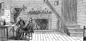
Yet what occurred here in April 1865 is far from the whole story. For decades, the Bennett family lived, worked, and likely even sang here. Then, in 1890, Brodie Duke bought the property with the hopes of displaying the home in the World’s Columbian Exposition in Chicago.
While this didn’t work out, the Bennett house had one more trick up its sleeve: it disappeared. The original house was burned down under mysterious circumstances, and what is on the property today is a reconstruction from local, period-appropriate materials.

Kitchen
This is a teaching kitchen recreated from old images and archeology of the house. Visitors have a chance to touch, view, and imagine the place where the Bennett family prepared their own food.

The Bennett family grew a lot of their food, but they also had to buy food they couldn’t produce at home. James Bennett’s account book provides a window into the kind of food items that the family couldn’t produce at home, including coffee and whiskey.

Hillsborough Road
This stretch of road follows the route that once connected Raleigh to Hillsborough. It’s significant to the Bennett Place story at the time of the surrender because it was this road where Johnston and Sherman were marching to meet each other with the intention of negotiating peace. The Bennett house was chosen as the meeting place only because it was the nearest house when the generals met. This video shares more about the Bennett Place Road.
But the road is part of a larger story going back to the original inhabitants of the region. This area was crisscrossed by Native American trading paths before Europeans colonized the area.
Unity Monument
The Unity Monument is made out of granite from the North, South, and West. Erected in 1923 to celebrate the reunification of the North and South, the monument was not received well by those who did not think the end of the Confederacy was worth celebrating. This created political pressure that ultimately impacted the dedication of the monument. What was meant to be a nationally recognized moment with a keynote speaker of equal national recognition became a smaller event where Julian Carr gave the address, the same speaker who gave an infamously racist speech at the dedication of UNC’s Confederate “Silent Sam” monument.
Nature Trail
Beyond its historic buildings, the Bennett Place property also features a wooded area complete with a nature trail. Although this area would have been part of the pasture during James Bennett’s time, today this area presents an opportunity to explore how forests grow as part of the larger environmental history of the region.

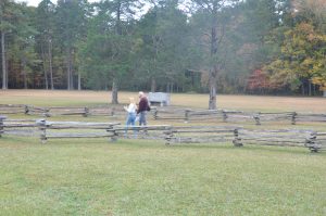
Historic Pasture
Before Europeans arrived, this land was the home of several Native nations, including Tutelo- and Saponi- speaking peoples. By the mid-18th century, the land had come under British rule and passed through a number of owners before James Bennett bought the property in 1846 and moved here with his family. Because of the soil type, this part of the Bennett farm was probably pasture. The fields were probably located north of the present-day Bennett Memorial Road. On their farm, the Bennett family produced staples for their own use and feed for their animals. The Bennett farm produced a lot of corn – about 250 bushels in 1850 alone to be exact. Learn more about corn in the 19th century for families like James Bennett or read this analysis of the James Bennett’s agricultural output in 1850 compared to his neighbors to learn more.
Sources
Markham Map, “First Settlers in Durham County- Early Land Grants”, 1750-1800, Duke Rubenstein Library
Mauldin, Erin Stewart. 2018. Unredeemed Land: An Environmental History of Civil War and Emancipation in the Cotton South. Oxford University Press.
Menius, Arthur C. 1981. “James Bennitt: Portrait of an Antebellum Yeoman.” The North Carolina Historical Review 305-26.
United States Department of the Interior National Parks Service. 1970. “Inventory-Nomination Form, Bennett Place State Historic Site.”