Triangle Day School

Next up for the Summer Camp Smart Commute Challenge is Triangle Day School (TDS), which offers summer camps for students ages four to fifteen. Eight weeks of camps run with various activities such as nature-based adventures, arts projects, STEM activities, literacy exploration, cooking & baking, and sports.

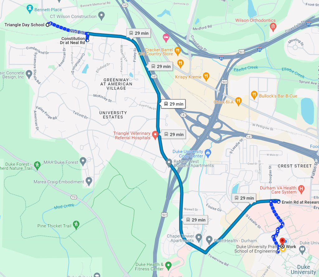
Located on Neal Rd. in northwest Durham, the lack of safe biking infrastructure makes it challenging to reach TDS on two wheels, especially with a kid. Luckily, a GoDurham bus route serves the American Village neighborhood just south of the railroad tracks and that same route goes right past Old West Durham! The closest bus stop to TDS is at Constitution Dr near Neal Rd. With some extra planning, time, and determination, TDS can be accessed from the 11B bus route, and the whole bus network, if you transfer at the Durham bus station.

Google Maps route from Old West Durham to Triangle Day School on the GoDurham 11B bus
Google Maps route from Old West Durham to Triangle Day School on the GoDurham 11B bus.

The 8 min, 0.4 mi walk from the bus stop is mostly sidewalk, but has a sidewalk gap near the railroad tracks.

Looking north up Neal Rd. from south of the railroad tracks
Looking west on Neal Rd. from east of the railroad tracks.
Looking north up Neal Rd. after the railroad tracks
Looking west on Neal Rd. from west of the railroad tracks.

The downside is that while Google Maps estimates just a 9-minute drive from my house, the one-way bus trip will take 30 minutes. To then get to work from TDS on the next bus, it will take another 30 minutes to reach my office at Duke. This is infeasible for most people, even with some working/reading on the bus using the free wifi. And while I’m considering it an adventure, it is a sobering reminder of the transportation challenges that many face on a daily basis.

Google Maps route from Triangle Day School to the Engineering Campus of Duke University on the GoDurham 11B bus
Google Maps route from Triangle Day School to the Engineering Campus of Duke University on the GoDurham 11B bus.


Duke Faculty Club Summer Camp

The Duke Faculty Club (DFC) Summer Camp is a day camp for rising first graders and up, who are ages 5 and up. Daily camp activities include games, sports, arts and crafts, and swimming. The day camp does not require the child’s family have a pool membership.

DFC is accessible from NC 751 (which is good for drivers, but bad for everyone else) or from Science Drive through Duke’s campus. The campus can be accessed from the south, east or north fairly safely, making Duke Faculty Club a destination one could bike to. There is also a GoTriangle bus that goes down Erwin Rd, which could be used to reach the camp, but it isn’t very frequent, and it would still require a 0.7 mile-long walk at the end.

Link to Route on Garmin

Erwin Road Needs More Crosswalks

Current conditions require up to a half-mile detour!

Erwin Road is the busiest bus corridor in Durham. GoTriangle, GoDurham and Duke Transit together have as many as 16 stops on this road. Erwin is up to six lanes wide, has high speeds, and has only one pedestrian refuge island (at a 3-lane section, lol). It can be deadly to cross without a crosswalk and pedestrian lights. So, I did a crosswalk audit on foot and followed it up with some Google Maps measurements of distances from bus stops to safe(r) crossings.

  • Coming from the west, the first bus stop is the worst: the westbound GoTriangle 400/405 bus stops across from the Duke Center for Living. The closest light is at Cameron, which would be 1100 ft detour to cross the street.
    However, there’s no crosswalk there and it’s five lanes wide. To actually use a crosswalk, it’s a 3000 ft detour to Morreene / Towerview. This is over a half mile, over a 10-minute walk in addition to waiting for the pedestrian signal!
  • Next is the GoDurham 11b and GoTriangle 400/405 stop at Morreene / Towerview. It requires a 790-foot detour and crossing a dangerous continuous-right turn “slip lane” to reach PruitHealth or Lenox Baker Children’s Hospital.
  • Third is the GoDurham 11/11b and GoTriangle 400/405 stop at Lasalle, a 550-foot detour to cross Erwin. This stop is used by pregnant patients going to the Fetal Diagnostic Center and people working at Dunkin, Chipotle, etc.
  • Next is the GoDurham 11/11b and GoTriangle 400/405 stop at Douglas / Research. The north side of the street has a decent stop with a shelter, but the south side requires a 720-foot detour to reach the apartments. This is a site of frequent mid-block crossings by pedestrian riders due to the layout of the crosswalks and placement of the bus stops.
  • Then the GoDurham 6, 11/11b and Duke Transit H5 stop east of Research requires a 610-foot detour to cross the street to reach Hock Plaza and the Saladelia Cafe.
  • Up next is the GoTriangle 400/405 stop near Fulton, the Duke Hospital, and VA. It is very close to light and crosswalk, but the road is six lanes wide here.
  • Finally the GoDurham 6 and GoTriangle DRX stop near Emergency Dr. is close to a crosswalk and light.
  • There are currently no bus stops east of Trent!
  • The only pedestrian island is at a marked crosswalk away from traffic lights at the Alexander intersection. This crossing should have a Hawk light and pedestrian push buttons if not a full traffic light.

Help me dig into these sidewalk guideline documents and demand better conditions for transit users and pedestrians:

If all we get in this update of Erwin Road is paint, let’s get the right paint in the right places to maximize safety for all vulnerable commuters.