UPDATE: we are now hosting EIGHTEEN (18!) Calendars: Grab the links below for any calendars you need or want. Menus are live now!
"DPS - Elementary School Lunch Menu": "e033ace1eabc7f445f279e48c1492cd0e5db67aef703ca0c93acb5d980d6ba84@group.calendar.google.com",
"DPS - Middle School Lunch Menu": "aa6e7d0349a33681b17ed1dcaeec77de4dd48c5c4cb3b88e5248d6970f974ea5@group.calendar.google.com",
"DPS - High School Lunch Menu": "f43adf5cc404f764f1117c696a46822123284ddd9fb29787fa24987307c6ce66@group.calendar.google.com",
"DPS - Breakfast in Classroom School Breakfast Menu": "df27dbb6e42cc1d73ea68a0b347d01045e0f675bed503de0d9398a553fdfef04@group.calendar.google.com",
"DPS - K12 School Afterschool Snack Menu": "bcfd3480f426a8d1990bd619f4a888aa2188047795925985e4bf9cc50080ac0d@group.calendar.google.com",
"DPS - K12 School Breakfast Menu": "7cda9ed521242ca7f784e4be49659ea7bd0e111254d624a484856d393a46185d@group.calendar.google.com",
"DPS - PreK School Breakfast Menu": "49070180e250dc55fc9b9fb50f8af587ca8f0d185d0071b0f8a0a165795fa47a@group.calendar.google.com",
"DPS - PreK School Lunch Menu": "f549af9de7f100ae4ffae580797d614a77e69ac66ebb022d4813a6c96de91b50@group.calendar.google.com",
"DPS - PreK School Snack Menu": "fe8ad901d2cf0c82cd5c432977a0fe373e5c636dcdc63c330e95c79953d703d6@group.calendar.google.com",
"DPS - Menú Almuerzo Escuela Elemental": "9d2d4085f41a4590166d8ffc53ddad4dda719e774d4d33199bc7a074c3644955@group.calendar.google.com",
"DPS - Menú Almuerzo Escuela Secundaria": "2bb8971f94aec9f659533e827184663b3a997a669f4fbe4c3d6251d664545c4d@group.calendar.google.com",
"DPS - Menú Almuerzo Escuela Intermedia": "25481c7e9c55e194b3a403147b08a60ebb7c172ed806fa1f415006ee4279e848@group.calendar.google.com",
"DPS - Menú Desayuno Escuela Desayuno en el Aula": "9f5ac2b3a512255654fc0c989b0e9f9cf2d01b0aaaa1a6ed0d476345d716fa72@group.calendar.google.com",
"DPS - Menú Meriendas Después de Clases Escuela K12": "79e83fe767d41b79f70f4166a2da3e2268fc08afef2054a24da82810ef4aa9e4@group.calendar.google.com",
"DPS - Menú Desayuno Escuela K12": "239a570eb9534fb421707056c2a6d66c9eceb64fa75d187f56b344759cf4e0da@group.calendar.google.com",
"DPS - Menú Desayuno Escuela PreK": "70397351d0ae781bdf4f70a2829c38dbf926fdd7d4878ff06537801710ee36ac@group.calendar.google.com",
"DPS - Menú Almuerzo Escuela PreK": "ab6c50f1b38abeafeaa860eecbc3bef1c838cb5849c8c7b2ed0ba5b61aa84635@group.calendar.google.com",
"DPS - Menú Merienda En la Escuela Escuela PreK": "588c0960558a35ba62c2e521cd0d648f54d09d67ea16d52f6625c67484745117@group.calendar.google.com"
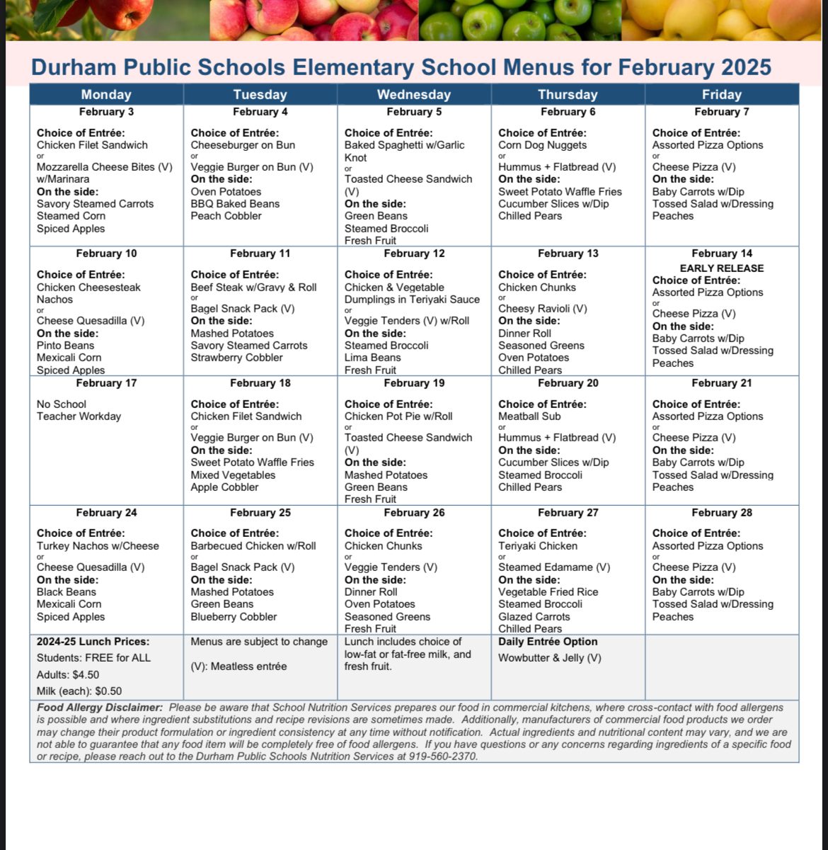
To their credit Durham Public Schools still has free lunch for all students, but my family has mostly packed lunch because mornings are busy and it’s a hassle to access the menus, which are only hosted as PDFs on a DPS website.
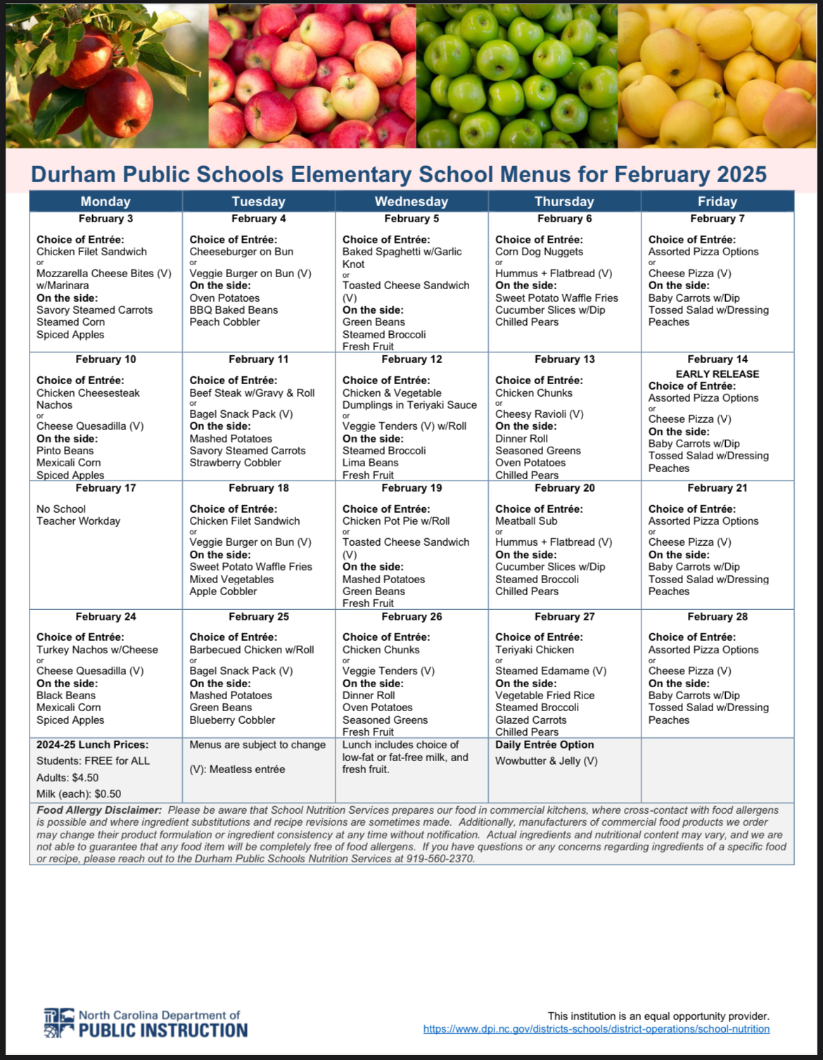
On mornings that I do remember about school lunch, I go to the website, download the PDF, open the file, check the menu and see if my kid will eat what’s offered that day or if we need to pack a lunch – too much friction. So, to make the menu more accessible, I recently worked on converting the PDF into a Google Calendar. With some Python code wrangling, and help from another programmer, I now have the DPS school menu calendars for English and Spanish for the current month for all three school levels! I can now see the menu alongside all my other calendars and events!
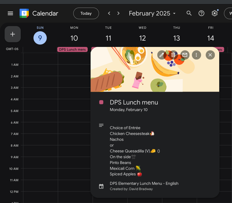
If this rocks your world, here are the links to add it to your calendar program of choice:
- Elementary
- Google Calendar https://calendar.google.com/calendar/embed?src=e033ace1eabc7f445f279e48c1492cd0e5db67aef703ca0c93acb5d980d6ba84%40group.calendar.google.com&ctz=America%2FNew_York
- iCal https://calendar.google.com/calendar/ical/e033ace1eabc7f445f279e48c1492cd0e5db67aef703ca0c93acb5d980d6ba84%40group.calendar.google.com/public/basic.ics
- Middle
- Google Calendar https://calendar.google.com/calendar/embed?src=aa6e7d0349a33681b17ed1dcaeec77de4dd48c5c4cb3b88e5248d6970f974ea5%40group.calendar.google.com&ctz=America%2FNew_York
- iCal https://calendar.google.com/calendar/ical/aa6e7d0349a33681b17ed1dcaeec77de4dd48c5c4cb3b88e5248d6970f974ea5%40group.calendar.google.com/public/basic.ics
- High
- Google Calendar https://calendar.google.com/calendar/embed?src=f43adf5cc404f764f1117c696a46822123284ddd9fb29787fa24987307c6ce66%40group.calendar.google.com&ctz=America%2FNew_York
- iCal https://calendar.google.com/calendar/ical/f43adf5cc404f764f1117c696a46822123284ddd9fb29787fa24987307c6ce66%40group.calendar.google.com/public/basic.ics
- Elemental
- Google Calendar https://calendar.google.com/calendar/embed?src=9d2d4085f41a4590166d8ffc53ddad4dda719e774d4d33199bc7a074c3644955%40group.calendar.google.com&ctz=America%2FNew_York
- iCal https://calendar.google.com/calendar/ical/9d2d4085f41a4590166d8ffc53ddad4dda719e774d4d33199bc7a074c3644955%40group.calendar.google.com/public/basic.ics
- Intermedia
- Google Calendar https://calendar.google.com/calendar/embed?src=25481c7e9c55e194b3a403147b08a60ebb7c172ed806fa1f415006ee4279e848%40group.calendar.google.com&ctz=America%2FNew_York
- iCal https://calendar.google.com/calendar/ical/25481c7e9c55e194b3a403147b08a60ebb7c172ed806fa1f415006ee4279e848%40group.calendar.google.com/public/basic.ics
- Secundaria
- Google Calendar https://calendar.google.com/calendar/embed?src=2bb8971f94aec9f659533e827184663b3a997a669f4fbe4c3d6251d664545c4d%40group.calendar.google.com&ctz=America%2FNew_York
- iCal https://calendar.google.com/calendar/ical/2bb8971f94aec9f659533e827184663b3a997a669f4fbe4c3d6251d664545c4d%40group.calendar.google.com/public/basic.ics
I hope these calendars save parents time, get more kids to eat the school lunch, and reduce social stigma around free lunch. With a little more work, this could probably be extended the remainder of the menus available on the DPS website for Whitted School, breakfast, etc. Even better, could DPS host Calendar files themselves?
I knew I had done something useful when within the first day of me posting it on the PTA email list serve I got these responses:
“Gods!! This calendar link is amazing! Thank you sooooooo much!!”
“Thank you!! Super helpful, much appreciated!!”
“David, this is seriously the best email I’ve ever gotten!!! Thank you so much, looking up the menu everyday was so annoying, and my only old-guy solution was printing it onto paper … AMAZING!”
“This is amazing, David. My kiddo will not eat at school anymore (infuriating) but I know a lot of people will truly get a lot out of this. And right now, using our superpowers for the greater good is all we got! And it is extra important. Thanks“
“You sir are the man! Well done!”
“Incredible”
“Not all hoagies wear capes. Thanks David!”
“Thanks David! … I’ve heard from a lot of folks that the menu situation is annoying. So definitely it would be valuable to host on ekpowe.org for families as well.“
“Works great!!! Thanks!”
“This is awesome. Thanks!”
“Those are serious superpowers, David! awesome!”
“This is fantastic! My son asks about the menu every morning and I love having it on my calendar.”