Guidance on the Ensemble Method for Analysing Redistricting Plans

[TLDR : See this PDF for guidance:  Ensemble Method Guidance ]

As the country gears up for the next redistricting cycle we have attempted to collect our thoughts and guidance on using the ensemble method to critique a particular redistricting plan. This summarizes our current thinking stretching back to 2013-2014 as one of the originators of the Ensemble Method; it reflects our experience gained through providing expert guidance, including live testimony, to the court in a number of cases.

The document begins with the following summary:

The ensemble of maps translates the specific redistricting design criteria into an understanding of what a redistricting plan should look like if the specified criteria are followed without ulterior motive. The criteria are formalized in a distribution on redistricting plans from which a sufficiently rich ensemble is drawn to capture the properties of the distribution. If the criteria are non-partisan then the ensemble gives a non-partisan normative collection against which other plans can be compared for their partisan and non-partisan properties.

The rest of the text can be found in this PDF document: Ensemble Method Guidance.

A slide deck on ensemble analysis, indices and county clusters

With the upcoming redistricting cycle, there are a number of questions about how ensembles can, will, and should be used to audit and restrict gerrymandering.

We have prepared a slide deck illuminating how the ensembles have been used to legally challenge plans during the last redistricting cycle.  We have also examined some of the new indices that are being put forward as measures of gerrymandering.  Under a certain set of votes, it is possible to “game” these indices, in the sense that plans can be typical of an ensemble according to multiple indices while still being gerrymanders.

Finally, for the North Carolina general assembly, we demonstrate the fragility and possible choices when it comes to county clustering.

The slides are available here.

Multi-Scale Merge-Split Algorithm

We have recently posted a pre-print of a Multi-Scale Merge-Split sampling algorithm.  The work’s central contribution is to provide a multi-scale representation of the state space which can be used to efficiently sample redistricting plans containing both fine and coarse-scale details.  Because of the coarse-graining, this algorithm promises fast scaling on problems with fine-scale graphs.  It also is capable of naturally preserving nested communities of interest (such as precincts made up of census blocks, and counties made up of precincts) without creating prohibitive energetic barriers which slow mixing. This work builds on our Merge-Split algorithm, which, in turn, builds on the ReCom algorithm.

Evolution of the state space
Convergence properties

Court Chooses to Stick with Relatively Unresponsive Maps

Today the state court chose to accept the Remedial Map which the legislature produced in response to the maps we have been using since 2016 being declared an illegal gerrymander in Harper v. Lewis.

Sadly this new map still has districts containing an abnormally large number of Democrats and others with comparably few. The result is a map which elects the same number of Democrats and Republicans over an abnormally large range of partisan election outcomes.

My analysis shows that the Remedial Map was much less sensitive to swings in the partisan vote fractions than the vast majority of the maps in the ensemble. The plots below, where the Remedial Plan is labeled HB 1029,  show that under a uniform swing analysis the nonpartisan maps in the ensemble often produce 6 and sometimes 7 Democratic seats in election environments when the Democrats perform well (a statewide vote fraction in the low 50%) for many sets of votes, while the 2019 Remedial Map reliably produces 5 Democratic seats in most instances. Each of the different plots uses a different set of historical votes (Labels: USS16- US Senate 2016, AG16 – Attorney General 2016, USH16 – US House 2016, GOV16 – Governor 2016).

The important feature is the atypically large jump between the 6th and 5th most Democratic district. This is the same “signature of gerrymandering” jump which we saw in Common Cause v. Rucho.  It makes the maps much less responsive to the  votes cast. They produce the same results over a large number of election scenarios.

The fact that the court felt it did not have time to investigate this fully shows how the judicial pathway of preventing gerrymandering is limited. We need legislative reform. It seems the only way to ensure that the maps used in elections are responsive to shifts in the political sentiment of the electorate.

More details can be found in the report I submitted to the court which can be found here: Mattingly Nov. 26 Declaration.

Jonathan Mattingly

Quantifying Gerrymandering in North Carolina – Revisited

We have revised our work quantifying gerrymandering in the N.C. Congressional Districts. The original work was presented in Common Cause  v Rucho. We have taken the opportunity to  use the improved code base which performs more sophisticated  convergence test and update our discussion to better reflect our current perspective. We have also corrected a few inaccuracies and small errors. That being said, the results are fully in line with those from the original version.

The new text can be found HERE.

A collection of related animations can be found “The Animated Firewall.” Two related discussions can be in It’s Not about Proportional Representation and The Fix is in: The votes don’t matter.

The data and code for this work can be found in this git repository: https://git.math.duke.edu/gitlab/gjh/nccongressionalensembles.git.


Majority and Supermajority Firewalls in the N.C. General Assembly

[Note: there is a known bug between WordPress and Safari; if the videos below do not render on Safari try switching to a different browser]

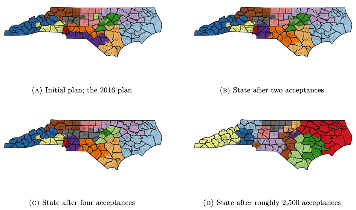
In our analysis of the 2017 North Carolina  General Assembly redistricting plan, one of our central findings was that the NC Legislature’s  2017 Redistricting Plan implement a firewall protecting Republican majorities and supermajorities.

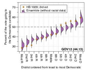
In trial, for the House districts, we showed animated bar-graphs that demonstrated how the range of democratic seat counts shifted with the statewide fraction of Democratic votes, under various shifts to historical elections.  For example, under the United States Senate vote in 2016, the enacted plan elects a typical number of democrats when compared to the ensemble when the statewide Democratic vote fraction is below 49%.  As the Democratic vote fraction rises to roughly 50.5% to over 52%, nearly all plans in the ensemble break the Republican supermajority, but the enacted plan remains stuck electing fewer than 48 Democrats to the state House.  As the Democratic vote fraction continues to rise, the enacted plan consistently elects fewer Democrats than the ensemble; at a Democratic vote fraction of 54.5%, nearly all plans in the ensemble predict a Democratic majority in the House, yet the ensemble retains a Republican majority.  The Republicans retain their majority in the enacted plan even when the Democratic vote fraction surpasses 55%; plans in the ensemble yield a strong majority to the democrats at this point.


The story is NOT about proportional representation, rather about how the #ncga 2017 maps (represented by arrow) systematically under-elect Democrats to a shocking degree.

The story is similar when using vote counts from the 2012 presidential race. Notice, in both videos, as the Democratic vote fraction rises to break the Republican supermajority in the ensemble, the enacted plan dramatically remains to the left of the majority/supermajority line.


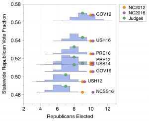
And as we examine more elections, the story still remains the same.  With Commissioner of Insurance votes from 2012, notice how Democrats are systematically under-elected by the #ncga 2017 Redistricting Plan when compared to our ensemble of thousands and thousands of non-partisan maps


Now with 2008 United States Senate votes. Getting worried about our democracy yet? Across many different vote patterns, same exceptionally atypical under-electing of Democrats persists. The effect is very robust across different offices, across different years.


Same story, now using votes from 2012 Governor election. Each election has a different spatial vote pattern, yet story persists. 2017 #ncga map under-elects Dems when they would typically gain more power. Notice map keeps a Republican majority even when some maps give Democrats a supermajority.


Finally, using 2016 Lt. Governor votes. Again same story.  The ensemble accounts for natural packing and the voting geography of North Carolina.  But natural packing is not enough to explain the enacted plan’s extreme Republican bias.  By comparing the enacted plan to the ensemble of non partisan maps, we separate the effects of natural packing from partisan gerrymandering.


Although the above maps will be remedied by the decision of Lewis v. Common Cause, many states are still highly vulnerable to the effects and consequences of partisan gerrymandering with no hope for remedy from the federal courts.  Map makers have inserted themselves in the electoral process and suppressed the Will of the People.  If you are worried about the state of our democracy, you should be.

Jonathan Mattingly
Gregory Herschlag

Optimal County Clustering in NC

North Carolina’s constitution requires that state legislative districts should not split counties. However, counties must be split to comply with the “one person, one vote” mandate of the U.S. Supreme Court. Given that counties must be split, the North Carolina legislature and courts have provided guidelines that seek to reduce counties split across districts while also complying with the “one person, one vote” criteria. Under these guidelines, the counties are separated into clusters. For a great explainer about the County Clustering problem see this blog entry on Districks.

A group of high school students from the NC School of Science and Mathematics worked with us over the last academic year and summer to develop computer algorithms to optimally cluster counties according to the guidelines set by the court in 2015. We recently released an article that presents the algorithm along with publicly accessible code which anyone can use.

Additionally, in our article, we use this to investigate the optimality and uniqueness of the enacted clusters under the 2017 redistricting process. We verify that the enacted clusters are optimal, but find other optimal choices. We emphasize that the tool we provide lists all possible optimal county clusterings. We also explore the stability of clustering under changing statewide populations and project what the county clusters may look like in the next redistricting cycle beginning in 2020/2021.

The posting to the ArXiv can be found here.
The article is now published and can be found here.
The code is referenced in the ArXiv post, and may also be accessed here.

[Edits: Added like to Districks  explainer (9/4/2019)]

The Fix is in: The votes don’t matter

One recurring theme we see is that the results in enacted maps are “baked in.” That is to say that over a wide range of elections  changes in the votes do not lead to changes in the partisan make up of the representatives elected. This effect was very pronounced in the N.C.  Congressional maps used in 2012 and 2016 . The enacted maps (NC 2012 & NC 2016) produce the same result over a large range of elections.   These elections have varying statewide vote fractions; the ensemble shows that the number of elected Democrats change as the elections change, whereas the enacted plans nearly always give the same result.

Here we have shown a number of historical elections and arranged them on the plot from most Democratic to most Republican. We see that as the Republican vote fraction  increases the blue histograms show that the typical number of seats elected by our ensemble of 24,000 or so maps shifts towards the Republican direction. The number of Republican seats elected by the Beyond Gerrymandering Judge’s map responds to the shifting public opinion by shifting the number of Republicans elected. The Enacted plans from 2012 and 2016 don’t change over a wide range.  In the enacted plan, the loss of support for a party does not result in the loss of seats.  In the ensemble and the judges plan, the loss of support for a party causes that party to lose seats.

This effect can be understood in the box-plot graphs of the ordered marginal plots.

The large jump in the plot, which leads to a range of election results for which the partisan outcomes don’t change, was has been referred to as the “Signature of Gerrymandering.”