- Fortifications of the city of Trogir: Visualising changes from 220BCE until 1900CE – February 6, 2019 Update
The aim of the project “Fortifications of the city of Trogir: Visualising changes from 220BCE until 1900CE”, as presented at DAH Venice 2018, was to collect data from different sources and to structure them into the GIS database. This GIS database was meant to be a scholarly output that would support schematic 3D models representing the changes and the development of Trogir fortifications during the long-time period. The data comprise the physical remains of the city walls, results of archaeological excavations, archival blueprints, historical maps and images, local historiography literature, notarial documents and scholarly literature.
Although it was obvious that the quantity and the quality of data before 1500CE and after were considerably different, the first plan was to split the work on collecting and analyzing data between Ana Plosnić Škarić and Ana Šverko around that year and produce a joint GIS database. The experiences learned from other participating projects made us reconsider. Therefore it was decided that APS would continue with the extensive work on structuring GIS database and producing schematic models, while AS proceeded to work on more detailed 3D presentations that would be achievable due to the sources from after 1500 that reveal more information. The majority of the materials from 1500 to 1900 are precise archival blueprints and photodocumentation from Croatian, Italian and Austrian archives, and documentation showing the current state of the fortifications. Along with supporting materials – detailed written historical, land registry and land survey records – it is possible to very precisely reconstruct the condition of the walls, particularly around the year 1800. It is thanks to the rich written and visual records that the documentation from this period served as a starting-point for the creation of the original 3D model of the Trogir fortifications.
Methodologies and visualizations experienced from other participating projects, during presentations and discussions on DAH Venice 2018 and on group monthly meetings, keep giving us new ideas and challenge us further.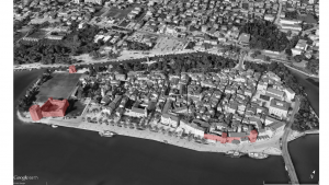
Trogir Fortifications preserved at full height, Google Earth 2019, APS
- DECIMA Update: January 31, 2019
Work on DECIMA 3D has continued since the conclusion of the seminar in Venice last June. Block by block, I (Eric) have been removing any modern structures from our 3D model to bring the number of polyhedrons into accordance with the Buonsignori map. Wherever there is a structure missing from the scale-back a building footprint is left where there should be one according to 1584. Generic models will be generated from these once the modern map has been policed for its post-sixteenth century features. I (Eric) have also been at work on DECIMA-related publication efforts. An article exploring the theoretical and technical considerations involved in creating the 3D GIS is currently at the proof-reading stage for the online journal DISEGNARECON. The current issue examines the limitations and potential of emerging technology for helping researchers understand historical urban environments, an extremely relevant subject considering DECIMA’s content!
Aside from these areas, we continue to deepen our current collaborations and explore new ones. Our partnership with Hidden Florence has supported a new postdoc for former DECIMA head RA Daniel Jamison. We’ve also developed four new tours for the Hidden Florence app that are being finalized now and should be available mid-March. Earlier in the fall, our co-PIs Profs. Nicholas Terpstra and Colin Rose hosted representatives from seven other digital humanities projects for a three-day workshop at Villa I Tatti outside of Florence. We’re considering serving as a visual platform, one that includes economic and demographic historical data, for these projects, all of which are art or architectural history ventures. The group, which includes historians from University of Virginia, William and Mary, and University of Chicago, is exploring applying for a Getty group grant and another partnership with the Innocenti (foundling hospital) in Florence.
We’ve enjoyed hearing updates from other groups since June, and look forward to continuing the conversation back in Venice!
- San Julián Project Update: January 31, 2019

Web presence of San Julián Project, work in progress
“San Julián de Samos: a digital approach” aims to study the architectural transformation of the monastic site of San Julián de Samos, in the northwest of Spain, over the course of centuries. This study includes the parallel evolution undertaken by its rural and urban surroundings, the sacred precinct and the nearby village. I utilize a multidisciplinary approach that combines historical sources, on-site investigation and digital technologies (2D CAD and 3D models) within the emerging field of Digital Art and Architectural History. The project addresses and visualizes questions of change and transformation over time that are crucial to analyze how the site was conceived, understood, and experienced as a sum of different parts instead of a single artifact.
After my participation in the June 2018 workshop “Visualizing Venice Summer Institute – Advanced Topics in Digital Art History: 3D and (Geo)Spatial Networks”, I set with the organizers two clear goals for our second meeting next June 2019; to make accessible the project through a web presence and to create an animation of the spatial evolution of the site. Both the web presence and the animation are currently works in progress, challenging me to explore new techniques in web development and animation making. In both cases, I took as references many of the projects presented during our two weeks in Venice.
Regarding the animation, it will show the design process and changes of the monastic site at Samos from the pre-monastic settlement to the secularization of this Benedictine community in the early 19th century. Thus, it is titled “Creating the Monastic Site: from the origins to the 19th century”. This animation could be used in a future exhibition in the monastery where the past of the monastic site is brought to life and told in an interactive way. I am in the process of applying for a grant from the Galician Regional Government to fund this exhibition at the monastery.
Developing the web presence of the project is a process that involves many technical challenges. First, it is necessary to say that all the files of the project generated from the archival documentation (2D maps and 3D models) are CAD files. The objects represented inside these files (roads, rivers, buildings…) have no attached historical data. Therefore, it was imperative to bring all of this files into QGIS (an open source Geographic Information System Application) to add the historical data attributes to the graphic objects.
Second, I needed to turn the QGIS files into an interactive map for the web presence. I evaluated two plugins for this purpose: QGIS Cloud and QGIS2WEB. With both it is possible to create interactive maps from the Shapefiles (SHP) defined in QGIS. However, the possibilities that these plugins offer to control how the interactive map is displayed and managed are limited. Through trial and error with these plugins, I learnt about Leaflet, an open-source JavaScript library for interactive maps. Currently, the Project is focused on developing the code with Leaflet along with HTML and CSS languages to create an interactive map. By making this project accessible through a web presence, new opportunities will be created to engage art, architectural, historical and cultural questions through interactive presentation and analysis.
- DAH: 3D Geo at College Art Association in February 2019
The Institute organizers will be sharing some of our experiences and initial findings at a special session at the College Art Association Conference on Wednesday, February 13, 2019. The session will take place at the New York Hilton, Concourse A, and will include diverse reflections on the Summer Institute.
- Victoria Szabo (Chair), “Digital Art History + Media Studies: Scholarly Encounters“
- Edward Triplett, “Making Visual Discoveries with 3D GIS“
- Mark J.V. Olson, “Advancing Digital Art History through Emerging Computational Paradigms“
- Hannah L. Jacobs,” “Project Management in Media Res: Strategies for Mid-Stage Digital Art History Projects”
- Paul Jaskot (Respondent)
Two of our Institute collaborators, Augustus Wendell and Estefanía López Salas will share project work in a poster session, “User Experience along the St. James Way. Intervisibility testing with agent based modeling at the monastery of San Julián de Samos.” This is a great example of a collaboration coming out of our work together – we hope to see a lot more of these collaborations take place within and outside the group, and to share our findings.
- Getty Research Blog Feature
The Getty Research Blog The Iris: Behind the Scenes at the Getty featured our Summer Institute projects on December 19, 2018. We will continue to develop the projects over the course of 2019 and will be updating our site with project news over the course of the next year.